Introduction
Subsurface exploration requires accuracy and safety. When you need to locate underground voids, hidden tunnels, or natural cave systems, you cannot rely on guesswork. You must work with equipment that reveals what lies beneath the surface without digging or causing ground disturbance. Modern caves and tunnels detectors allow you to detect cavities, hollow spaces, and geological formations using advanced scanning technology. The biggest breakthrough is real-time visualization, which gives you instant underground imaging.

This article explains how cave detectors work, how real-time visualization improves on-site decisions, and why Gold GPR is widely trusted for high-precision cave detection. You will learn the essential features to look for, how to interpret readings, and how to use the equipment effectively in field conditions.
Understanding Cave Detection Technology
Why Cave Detection Is Important
Underground cavities can exist naturally or be the result of historical excavation, mining, architectural construction, or geological erosion. Before building, drilling, digging, or exploring, you must confirm the stability and structure of the ground. Unidentified underground cavities can cause soil collapse, building failure, drain collapse, mining accidents, or archaeological damage. With reliable cave detectors, you can evaluate ground structure safely and accurately.
What Cave Detectors Do
Cave detectors identify differences in underground density to detect empty pockets beneath the surface. These pockets may be caves, tunnels, chambers, mine shafts, or any void formation. When the equipment scans the ground, it sends signals into the subsurface and reads the reflected signals to determine where material density changes.
A caves and tunnels detector can reveal:
Natural cave formations in mountain, desert, and karst terrain
Man-made tunnels and underground chambers
Abandoned mine shafts, bunkers, or war shelters
Lava tubes and geological void networks
Soil collapse zones where sinkholes may form
Water drainage tunnels and underground river channels
Technology Behind Modern Cave Detectors
Modern cave detectors operate using one or more detection principles. The most advanced systems today use:
Ground Penetrating Radar (GPR)
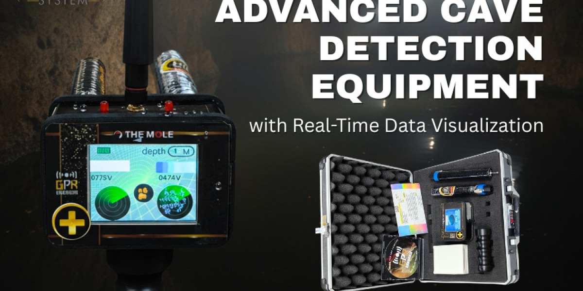
This technology sends radar waves into the ground and measures the reflections. Differences in reflection patterns indicate where soil density changes. Air-filled cavities show clear, recognizable gaps. Gold GPR systems specialize in deep-penetration GPR scanning with high image clarity.
Magnetometry
Underground tunnels and chambers created by humans often disturb natural magnetic balance. Magnetometers detect such disruptions, helping identify man-made voids.
Seismic and Acoustic Reflection
A controlled sound or vibration is sent through the ground. The returning signal reveals variations in density and shape.
Electrical Resistivity
Electric current is passed through the ground to detect conductivity variations. Different soil types and voids conduct electricity differently, helping outline underground structures.
Each technology is guided by the type of terrain, depth requirement, and nature of the suspected cavity. Gold GPR systems use radar-based subsurface imaging because of its clarity, speed, and real-time display capability.
Real-Time Data Visualization: A Transformational Feature
What Real-Time Visualization Means
Older detection systems required you to perform a scan, store data, return to a computer, and process data later. Interpretation required trained experts and extended time.
Real-time visualization transforms this process. Now, you can see underground layers instantly as you walk and scan. The detector continuously updates the display to show changes in subsurface density and structure.
Benefits of Real-Time Imaging
With real-time imaging capabilities, you can:
Identify underground cavities immediately
Mark exact GPS coordinates on the spot
Avoid scanning the same zone repeatedly
Evaluate ground safety instantly before excavation
Understand depth and scale without delay
Confirm whether an area requires further investigation
Why Real-Time Imaging Improves Safety
Ground collapse is one of the most dangerous risks when dealing with caves or tunnels. Real-time visualization helps you locate unstable soil layers and weak ground zones quickly, reducing the chances of stepping onto or working above an unrecognized void.
Applications of Cave Detection Systems
Archaeology and Heritage Preservation
Archaeologists must work carefully around fragile underground structures. A misplaced excavation can cause irreversible damage. Cave detectors allow non-invasive surveying, letting you locate and map old underground corridors, tombs, temples, and hidden chambers without disturbing the site.
Mining and Resource Development
Miners must know where cavities exist to prevent tunnel collapse and equipment loss. Advanced scanning helps define safe drill zones and supports long-term structural planning.
Civil Engineering and Construction
Before constructing foundations, bridges, tunnels, highways, dams, or pipelines, engineers must confirm the ground’s internal stability. Caves and tunnels detectors help avoid building on unstable or hollow soil.
Environmental and Geological Research
Geologists use subsurface imaging to study underground rivers, collapsed limestone networks, karst landscapes, and erosion patterns.
Security and Defense
Military and security agencies use cave detection systems to locate smuggling tunnels, illegal bunkers, escape routes, and hidden underground networks.
Gold GPR: High-Precision Cave Detection Solutions
What Makes Gold GPR Different
Gold GPR specializes in radar-based cave detection systems designed to deliver high-resolution imaging even in complex ground conditions. The systems are built to be field-ready, durable, and easy to interpret.
Core Advantages of Gold GPR Systems
Deep scanning range for small and large voids
Real-time 2D and 3D visualization modes
Adjustable frequencies to match terrain type
Portable scanning units for difficult environments
GPS integration for accurate mapping
Data storage and export for professional reporting
Rugged build quality designed for field operations
Why Operators Prefer Gold GPR
You gain:
Faster, clearer understanding of underground structure
Higher accuracy compared to traditional sonar and magnetometer systems
Quick learning curve — no need for advanced data science skills
Consistent performance in sand, limestone, rocky ground, and gravel
How to Choose the Right Cave Detector
Determine Required Scan Depth
If you are mapping shallow cave networks, you may not need deep-penetration frequencies. For mountain caves, volcanic formations, or historic tunnel systems, deeper scanning capability becomes necessary. Choose based on your survey objective.
Assess Ground Type
Soil composition affects radar signal clarity. Wet clay, dry sand, basalt rocks, limestone, and mixed gravel each respond differently. Systems like Gold GPR allow adjustable frequency controls to optimize detection across different terrains.
Evaluate Image Clarity
Real-time visualization must be sharp and readable. Look for clear void outlines that make cavity shape recognizable. Poor clarity increases interpretation errors.
Check Field Portability
Detection often requires long walking routes through uneven terrain. Portable and ergonomic detectors reduce fatigue and improve survey coverage.
Look for Reporting and Data Export Tools
Professionals often need documented scan results. Choose equipment that logs data, embeds location references, and exports scan maps.
How to Interpret Cave Detection Data
Reading Density Variation
Voids appear as low-density regions. Solid rock appears denser. The gap between these densities forms the outline of a cavity.
Recognizing Natural vs. Man-Made Shapes
Natural caves are irregular and curved. Man-made tunnels show straight or geometric boundaries. Real-time visualization helps you identify the origin of the cavity.
Understanding Depth Indicators
The detector displays depth estimates based on return signal timing. Adjusting frequency ensures more accurate depth calculation.
Field Operation Guide: Step-by-Step
Plan your scan area and define the grid pathway.
Power on the Gold GPR device and calibrate according to terrain.
Walk steadily across the survey zone without abrupt movement.
Observe real-time screen for void signatures and ground anomalies.
Mark coordinates when anomalies are detected.
Scan again from a different angle to confirm shape and depth.
Export scan data and generate a 3D map for documentation.
Common Scanning Challenges and Solutions
Wet Ground or High Moisture
Water absorbs radar waves. Lower scanning frequency improves penetration in these conditions.
High-Density Rock Layers
Dense materials may distort reflections. Adjust scanning angle and frequency to compensate.
Uneven Terrain
Use stabilization carts when possible for consistent scanning motion.
Why Real-Time Visualization Is a Breakthrough
Real-time scanning removes guesswork. You no longer need to wait for data interpretation or rely on uncertain assumptions. You get immediate clarity, faster decisions, safer operations, and precise mapping accuracy. This improves effectiveness across construction, research, mining, archaeology, and security fields.
Conclusion
Modern caves and tunnels detectors allow you to explore underground environments with accuracy, safety, and confidence. Real-time visualization gives you instant understanding of what lies beneath the surface, helping you avoid collapse zones, identify safe access points, and document underground formations clearly.
Gold GPR provides advanced cave detection equipment designed for high-resolution imaging, portability, rugged field use, and professional-level scan interpretation. When you choose high-performance cave detectors, you gain the ability to see the unseen world below the ground with precision and clarity before you ever break the surface.
You can now make safer, faster, and more informed decisions in exploration, planning, research, and excavation.