The Bangalore Metro Route Map is the lifeline of the Silicon Valley of India. With a growing population and expanding tech hubs, Bengaluru's Namma Metro has transformed urban commuting. Residents now rely heavily on this fast, efficient, and eco-friendly mode of public transport.
As per recent expansions and updates, the metro now connects many critical zones—from tech parks and residential hubs to educational institutions and cultural centers—making the city more navigable than ever.
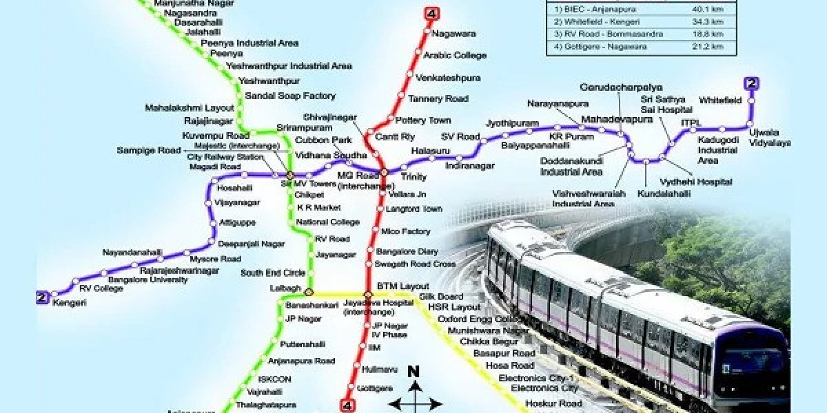
Explore the Bangalore Metro Route Map to stay informed about all lines, station connectivity, and timings. This guide provides you with everything you need to travel seamlessly across Bangalore.
Overview of Namma Metro
Bangalore Metro, also known as Namma Metro, was inaugurated in 2011 and is managed by Bangalore Metro Rail Corporation Limited (BMRCL). It’s the first metro system in South India and is expanding steadily to serve a growing city.
Quick Highlights:
Operational since: 2011
Managing Body: BMRCL
Total Lines (2025): 3 operational, 2 upcoming
Mode: Elevated and underground
Connectivity: Tech parks, CBD, educational institutions, airports (future phases)
Current Bangalore Metro Route Map (2025 Edition)
1. Purple Line
The Purple Line is the oldest and one of the most frequently used metro lines in Bangalore. It connects the eastern and western parts of the city.
Key Stations:
Baiyappanahalli
Indiranagar
MG Road
Vidhana Soudha
Majestic (interchange with Green Line)
Vijayanagar
Kengeri
Timings:
6:00 AM to 11:00 PM (with peak hour frequency of 5-10 mins)
Major Connects:
Educational institutions, shopping districts, and government offices
2. Green Line
The Green Line travels from the north to the southern parts of Bangalore, passing through important business and residential zones.
Key Stations:
Nagasandra
Yeshwanthpur
Mantri Square Sampige Road
Majestic (interchange with Purple Line)
Lalbagh
South End Circle
Yelachenahalli
Silk Institute
Timings:
6:00 AM to 11:00 PM
Major Connects:
Textile hubs, parks, and residential neighborhoods
3. Yellow Line (Upcoming/Partial Operation)
The much-awaited Yellow Line is in advanced stages of construction and trial runs. It aims to connect the southern IT corridor with the heart of the city.
Proposed Route:
RV Road
Ragigudda
JP Nagar
Central Silk Board
HSR Layout
Bellandur
Iblur
Marathahalli
Kadubeesanahalli
Outer Ring Road
Hebbal (eventual link)
Timings:
Expected operational hours: 6:00 AM to 10:30 PM
Major Connects:
Tech corridors, Outer Ring Road, ITPL (future links)
4. Blue Line (In Progress)
The Blue Line, once operational, will be a game changer for air travelers as it plans to connect Kempegowda International Airport (KIA) with the city.
Proposed Route:
KR Puram
Nagawara
Hebbal
Jakkur
Yelahanka
KIA Terminal
Timings:
To be announced post-commissioning.
Major Connects:
Airport, business hubs, and residential clusters in northern Bengaluru
5. Pink Line (Proposed)
The Pink Line is in the planning phase and is expected to further improve east-west intra-city travel.
Planned Route:
Bannerghatta Road
Dairy Circle
Richmond Town
Shivajinagar
Nagawara
Status:
Awaiting final nod for construction initiation.
Bangalore Metro Timing and Frequency
| Day | Start Time | End Time | Frequency (Peak) | Frequency (Off-Peak) |
|---|---|---|---|---|
| Monday - Friday | 6:00 AM | 11:00 PM | 5 mins | 10 mins |
| Saturday | 6:00 AM | 11:00 PM | 7 mins | 12 mins |
| Sunday / Holiday | 7:00 AM | 10:00 PM | 10 mins | 15 mins |
Note: Timings are subject to operational changes during festivals or maintenance.
Metro Interchange Stations
Interchange stations are crucial for commuters who need to switch lines.
Majestic Station – Interchange between Purple and Green Line
Jayadeva Hospital (Upcoming) – Interchange for Yellow and Blue Line
Silk Board Junction (Upcoming) – Proposed multi-line interchange
Nagawara (Future Link) – Interchange for Blue and Pink Line
Last-Mile Connectivity Options
One of the strengths of the Bangalore Metro Route Map is the provision for last-mile connectivity through:
Feeder buses run by BMTC
Electric scooters and rental bikes
Ride-hailing services
Dedicated pedestrian walkways and cycling tracks
Metro stations like Baiyappanahalli, MG Road, and Yelachenahalli are integrated with bus stands or parking bays for convenience.
Smart Ticketing and Metro Card
To enhance user convenience, Namma Metro has introduced:
Metro Smart Cards for cashless travel
Mobile App QR Tickets
Recharge at station kiosks or online portals
Daily, Weekly, and Monthly Passes (for frequent commuters)
This reduces ticketing queues and encourages seamless entry/exit at stations.
Metro for Bangalore’s Future
The metro isn’t just solving current traffic woes—it’s being designed to shape the city's future.
Economic Boost: Real estate and retail have flourished near metro stations.
Environmental Gains: Reduced vehicular emissions, congestion, and fossil fuel use.
Inclusive Transit: Ramps, elevators, tactile flooring, and priority seating for elderly and disabled commuters.
Nearby Landmarks on Metro Map
Educational Institutions
Christ University (Hosur Road) – Nearby Yellow Line
Mount Carmel College – Close to Green Line
RV College – Near upcoming Yellow Line stations
Hospitals
Jayadeva Hospital – Directly connected via Yellow Line
Fortis – Accessible from Green Line
Victoria Hospital – Near Purple Line
Shopping & Leisure
Orion Mall – Next to Yeshwanthpur Station
Phoenix Marketcity – Accessible from Baiyappanahalli
Brigade Road – MG Road Station on Purple Line
Bangalore Metro Route Map & Expansion Plans 2025–2030
Future plans include:
Phase 3 of expansion connecting suburbs like Whitefield, Sarjapur, and Electronic City
Airport Link via Blue Line – Enabling faster airport travel
Ring Metro System – Loop line for intra-city circulatory movement
Metro Neo & Light Rail – For Tier-2 corridors within city limits
These additions are expected to further increase the coverage and passenger convenience.
10 FAQs About Bangalore Metro Route Map
When did Bangalore Metro start operations?
→ In 2011.How many lines does Bangalore Metro currently have?
→ Three active, two upcoming.What is the timing of Namma Metro?
→ 6:00 AM to 11:00 PM on weekdays.Can I switch lines in Majestic Station?
→ Yes, between Purple and Green lines.Is there a metro station at Kempegowda Airport?
→ Coming soon via Blue Line.Does Bangalore Metro accept smart cards?
→ Yes, including QR code tickets.Is there a station near Marathahalli?
→ Planned under Yellow Line.Are there feeder buses at metro stations?
→ Yes, at major stations.Is Bangalore Metro safe for women and elderly?
→ Yes, with CCTV and designated coaches.What’s the frequency of trains during peak hours?
→ Every 5 minutes.
Conclusion
The Bangalore Metro Route Map reflects not just a transport network, but the evolving spirit of a city that is fast, connected, and future-forward. Whether you’re a daily commuter, an occasional traveler, or a newcomer, Namma Metro has transformed how the city moves.
From the historical lanes of Vidhana Soudha to the tech corridors of Electronic City, every route, every station, and every connection has a story to tell—and more are being written every day.
With new lines under construction and future phases on the horizon, Bangalore’s metro journey is just beginning. The aim is to ensure no neighborhood is left unconnected and that the people of Bengaluru have access to a reliable, eco-friendly, and fast urban transit system.
To understand this dynamic network better, refer to the Bangalore Metro Route Map and plan your journey today.